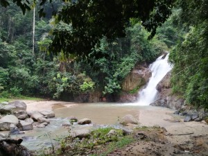
We’re back at the beautiful waterfall at Sungei Dua.
Venue: Sg.Dua Waterfall, Karak, Pahang
Travel Time: 80+ minutes
Date: Sunday 2nd June 2019
Registration: 13:15 – 13:45
Run Starts at: 14:00
Hare: Grigolo family
Co-Hare: Lai
This time, our run-site is actually down beside the main waterfall – this is different from our last run here, where we parked by the village hall a few hundred metres back down the road.
The road down to the waterfall has been improved since our last visit, but there is only space for one or two cars down there, so most of us will need to park at the top and walk down.
When you get close, look out for the usual yellow bunny hash signs, until you reach a ‘U-turn’ bunny sign which indicates the general area to park in.
The local community makes a small charge for access to this run-site, to fund conservation work (including collecting litter) and keep the numbers of visitors to manageable levels. This is usually collected on the road leading to the run-site, and the hare has discussed a fee of RM2 per adult (nothing for kids), so hopefully that will be the rate on the day. Please tell the person collecting the fee that you are going to a kids’ picnic at the waterfall.
Cold drinks and hotdogs (halal – made from premium Victoria Crest sausages) will be available.
Directions:
WAZE: Sg.Dua Waterfal
Or easy to follow written instructions.
From KL take the Karak highway E8 and drive towards Karak.
About 42 km after the first toll in KL, arrive at the Bentong toll-gate.
Set the trip meter to zero at the Bentong toll.
14.5 km: Turn off the highway at Exit 813A sign-posted PUSPEN KARAK
When you drive down the slipway, you are in Kampung Cinta Manis.
14.8 km: at the bottom of the exit slipway turn right and go through the tunnel under the highway
Immediately after the tunnel turn right again (effectively a U-turn) and go back on the highway (E8) in the direction of KL
16.1 Km Drive slowly on the highway and keep left. At KP 75.4, exit the highway. This is not an official exit, so keep a close watch.
Climb up a steep slope branching off to the left. After 100 m at the top of the climb, follow hairpin turn right and double back, down the slope and follow the tarmac road.
17 km Cross a bridge, follow tarmac road through a Kampung. The river is on your left hand side.
The road starts to climb after you pass the kampung.
19.3 km You’ll hit another small kampung, with a turning left over a bridge, but we keep straight for about 400m. When you see a track leading down to the left (to the waterfall), look for parking opportunities on the road at the top – don’t try to park down the track towards the waterfall.
Leave a Reply