Venue: the waterfall behind Hulu Selangor Science School, Ulu Yam
Travel Time: 60-70 minutes
Date: Sunday 4th August, 2019
Run Starts at: 2pm – aim to be there for 1:30 (or come even earlier for a picnic lunch)
Hares: Rosely and French families
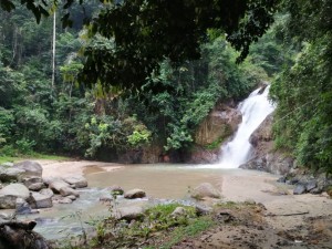
This is a popular site that we visit most years, and the small waterfall is perfect for August when our turnout isn’t as high as usual.
The science school is at the junction of Persiaran Antara Gapi and the main Ulu Yam – Batu Caves road, just a couple of km from Ulu Yam Baru town. We take the side road that turns off about 100 metres along Persiaran Antara Gapi, to go behind the school and almost to the new ‘Flamboyant Resort’.
There is a small waterfall with pools above and below it – perfect for splashing around to cool off after the run (short – 2km or long – 4km).
As usual, we will have cold drinks and hot dogs (made with Victoria Crest sausages), so bring a little pocket-money.
Directions:
The run-site is at 3.406167,101.659
If you click one of these icons, it will direct you to the run-site:
![]()
![]()
There are at least 3 good ways to get there, depending on traffic and your starting point:
- one way is to go up the Batu Dam road behind Batu Caves
- another is up the old Ipoh Road, and then on the shiny new bypass around Rawang to Serendah
- a third way is described in detail below:
Via the N-S highway
– Go North (towards Ipoh), and take exit 117, for Sungei Buaya (this is the relatively new exit between Rawang R&R and Bukit Beruntung)
– After the toll, turn left at the traffic lights
– Go straight (winding road) for just over 2km until you reach traffic lights
– Turn right at the lights, towards Serendah/Rawang
– Drive straight for about 3km, passing the Perodua factory, until you hit the old highway 1 at Sungei Choh
– At this junction, keep in the far left lane (there is usually a queue to turn right) and turn left towards Serendah / KKB / Ipoh
– Drive for about 10km until you see a traffic-light junction with colourful new (mostly empty) shop-lots on your left
– Get into the right-hand lane, and turn right at the lights, into Antara Gapi
– Drive along Persiaran Antara Gapi for 5km, until the science school is on your right – this is only about 100 metres before the Ulu-Yam – Batu Caves road, so if you reach that road then you’ve gone a tiny bit too far
– turn sharp right (180 degrees) onto a small road that leads behind the school
– follow this track (and hash signs) until you reach the run-site, by a small bridge across a stream
Follow directions to park considerately.
On On!