Venue: Old Nambi Estate, near Rasa, Selangor
Travel Time: 75 – 90 minutes
Date: Sunday 6th May, 2018
Registration: 14:15 – 14:45
Run Starts at: 15:00
Hare: Oakley family
Rumour has it that a couple of families will camp out on the Saturday night. If anyone is keen to join them do let us know (e.g. via Facebook) in advance, so they don’t get scared by noises in the night!
Cold drinks and hotdogs (halal – made from premium Victoria Crest sausages) will be available.
Directions:
GPS: GPS: 3.490858, 101.666389 or 3°29’27.35″N 101°39’58.53″E
But do not simply head straight for those GPS coordinates, or you might end up on a long track from Batang Kali – go via Rasa Chinese Cemetary.
Google map here
WAZE:
“RASA CHINESE CEMETERY”
will take you to the gravel road where you can then follow hash signs
WAZE: Open in Waze
In case of any small changes on the day, follow the usual yellow bunny hash signs.
For traditionalists, you could follow the directions below (there are also good alternatives, e.g. past Batu Caves and up the new Rawang bypass, or via the N-S highway to Bukit Beruntung):
From KL Head North on NKVE and Exit 117 for Sungei Buaya / Serendah.
Reset Trip Meter at Toll
350m Turn left onto Route 1208
Go straight (winding road) for just over 2km until you reach traffic lights
Turn right at the lights, towards Serendah/Rawang
Drive straight for about 3km, passing the Perodua factory, and keep in the left lane as you approach the old highway 1 at Sungei Choh.
Approx 7km: turn left at traffic lights onto route 1, towards Serendah / KKB / Ipoh
26km (just after bridge and road sign to Rasa on left) Turn Right, following hash signs onto gravel road at cemetery.
Follow Hash signs for a further 3.6km, to the run-site.
P.S. Mother’s Day is the following Sunday, 13th May, but we think all the mummies would love a tranquil jungle experience this weekend!
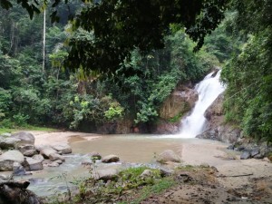 Either way its worth a visit and either way there is still a nice river next to the run site so bring swimmers.
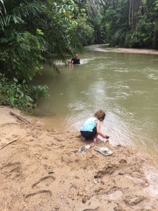 We’ve been promised a epic run from our friend Denis with an amazing river to play in/cool down afterwards…